Hiking
Extra Information
Be sure to check on current conditions before planning trips, weather changes so much so often.
> > > Park Condition Report (Kachemak Bay State Park)
Important safety reminders! https://www.friendsofkachemakbay.org/trails-home
Make your next trek amazing.
Kachemak Bay State Park is the first SP in Alaska. Accessible by boat or plane, trails are uniquely remote while being in reach for nearly everyone. Check out your options.
TRAILS
Grewingk Glacier Lake Trail—Book online, call for alternative times or if the trip is full!
Easy
The most accessible and popular hike in the park starts on the beach at Glacier Spit. Climb up the berm, meander through a mature cottonwood forest, cross a glacial plain and then wind up at a wide gravel beach at the edge of the lake. Great place to have a picnic, take pictures of icebergs and the glacier, and cool your feet! When you’re ready, backtrack to the Saddle Trail, make your way about 500’ up through the spruce forest, and switchback down to your pickup. Total distance about 4.2 miles, total time 4 to 4.5 hours. This hike can also be an out and back on the Saddle Trail, which takes about 3 hours and is about 3 miles.

Grewingk Lake, fall
Saddle Trail—Call or email to book!
Easy-moderate
The Saddle trail gives you access to the Grewingk Lake area, the tram, Humpy creek and Alpine ridge. Most people end their trek to Grewingk Lake here, and it can be used as an up and back to the lake if you have less time. It adds flexibility. Connects to the Lagoon trail, and so to the China Poot lake trail system. Starting in Halibut cove, a steep stairway leads to a platform at the beginning of a set of switchbacks, up the steep hillside above the cove. Follow the trail for about 1/2 of a mile to the junction of the Alpine Ridge Trail at the top of the climb. Your elevation gain is about 500’. Continue straight towards Grewingk Lake. Another 3/4 mile of forested trail will take you down the other side of of the Saddle to the junction of the Glacier Lake trail where you can connect up to the trails to the north by turning left, or go to Grewingk Lake by turning right.
“What a great way to see Alaska!!! Water taxi to our hiking trail. Hiked to the glacier and across the saddleback trail. Pick up 4 hours later right on time. Spent time whale watching in the cove. Magical day, great people!!!”
Email or phone us to book! ashorewatertaxi@gmail.com +1(907)235-2341Tram Trail Spur
(to Grewingk Tram and beyond)
Easy
At mile 1 on the Grewingk Lake trail, you’ll come to a spur on your left leading to the Grewingk Tram. The tram crosses the Grewingk river, and lets you access trails on the N. side of Grewingk flats. The tram is suspended on cables, and is operated by hand. It’s nice to have two (or more) people to operate it, as it is somewhat heavy. It’s a fun side trip to include on your walk to Grewingk Lake. Total distance (there and back) 2 miles. total time aprox. 1 hour depending on how much you feel like playing around!
Email or phone us to book! ashorewatertaxi@gmail.com +1(907)235-2341Humpy Creek Trail—call or email to book!
Easy
This trail starts near the Humpy Creek Yurt. It is mostly flat, traveling W. towards the Grewingk River and the Grewingk Tram. You’ll follow a mixed forest trail for about 1 mile, eventually coming out on the river flats between Foen ridge and the river. Take Note: The woods here are damaged by a large spruce bark beetle outbreak that happened in the late 80’s, so make sure and check with your water taxi about conditions before you attempt. Trees often get blown down over the winter. Follow cairns and markers past some kettle ponds and rocky areas until you come to the Grewingk tram. From there, it’s up to you where to go!
Email or phone us to book! ashorewatertaxi@gmail.com +1(907)235-2341Alpine Ridge—call or email to book
Difficult
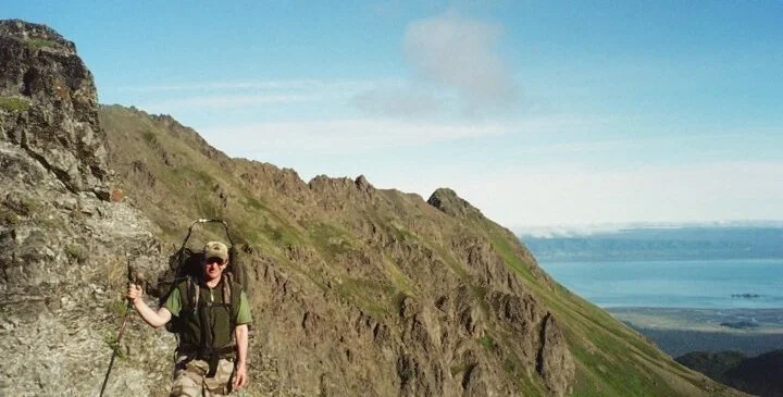
Access this hike from the Saddle trailhead. When you get to the top of the saddle, a sign will direct you uphill towards the high ridge overlooking Grewingk Lake and Grewingk Glacier. This trail climbs steadily and at times steeply, up to tree line and finally to an alpine bench. You can wander around up on top, find little pothole lakes, take in the beautiful mountain views in every direction, look for black bear and mt goats on the surrounding slopes and take a good rest. Total distance about 4 miles, total time 5-6hrs depending on how long you spend wandering.
Kanda the wolf dog.
Email or phone us to book! ashorewatertaxi@gmail.com +1(907)235-2341Blue Ice Trail—call or email to book!
Moderate

Glacier
Start at Glacier spit, and hit the trail to Grewingk Lake. At mile 1, take the tram trail to the Grewingk River tram, and make your way across. Once on the other side, you’ll climb Foen ridge, where a short (500’) but somewhat steep climb will take you to a great overlook on a lovely cliff. Take it in and continue down Foen. The trail continues SE along the N side of Grewingk flats, which is open cottonwood forest and easy walking. After about another mile, you’ll come to the N. side of Grewingk Lake, where the trail starts to climb fairly gently up increasingly rocky terrain .You’ll top out on the glacial moraine just above Grewingk itself. Take note!: There was a recent large calving event on the glacier which caused it to retreat substantially, since then approaching within touching distance has become difficult. Take in the spectacular view, you are right up against the active ice and can hear it groaning and sighing... Return the way you came, but when you hit the Grewingk lake trail, turn left and go to the Saddle trail. Follow the Saddle trail to your pick up at the trailhead in Halibut Cove. This hike is long, about 13 miles total, and can take 10 or more hours. Plan on having a full day of fun, and give yourselves plenty of time to enjoy the varied terrain and incredible views.
Email or phone us to book! ashorewatertaxi@gmail.com +1(907)235-2341China Poot Lake Trail System—call or email to book!
Moderate
Starting in Halibut Cove Lagoon, this trail connects you to the Coalition Loop trail, the Moose Valley trail, China Poot Peak trail and the Woznesinski River trail. Most people use it to get to the China Poot lake, or Moose Valley, public use cabins, so I’ll describe it from the drop off point at the dock, to the cabin at China Poot Lk. You can also access from the West cabin on the lagoon. From the ranger station, a short stretch of trail (estuary trail) scrambles up from the dock and climbs for about .5 miles to the China Poot Lake trail. You’ll climb quickly to First Lake, top out at about 500’ where you’ll start meandering up and down towards Moose Valley. About mile 2, you’ll reach the Moose Valley trail, and continue right towards CP lake. Coalition Loop trailhead is next, and then some wet meadows that end at China Poot lake. Great place to relax and fish for rainbow trout! Ask about trail conditions before your trip, things change every year. Total time about 2.5hrs, total distance about 3 miles.
For specific hiking info on the other areas accessed by this trail, email or call with your questions!
Poot Peak on way to Moose Valley
Email or phone us to book! ashorewatertaxi@gmail.com +1(907)235-2341Grace Ridge Trail—call or email to book!
Moderate-Difficult
This is another very popular day hike, offering fantastic alpine views and a nice through trail. You can start from the north or south end of this trail, depending on any plans you may have for camping. I’ll describe briefly from the south end. You’ll begin at the South Grace trailhead, near the tutka 1 yurt. Switchbacks take you through old growth spruce forest and a large swath of alders and brush, down through a creek valley, and then back up very steeply to a knife edge ridge that continues climbing (steeply) to alpine. You’ll plateau briefly on the very open southern end of the ridge, and then climb steadily, though not too steeply, towards the summit at just around 3200’. The views of Tutka bay on your left, and Sadie cove on your right from the steep stretches are fantastic, as are the mtn views, and on nice days, a peek at the Gulf of Alaska waters. You can often spot mt. goats, marmot, ptarmigan, and black bear from the slopes. Really my favorite hike! Total distance is around 10 miles, total time anywhere from 6 to 8 hrs depending on your hiking speed and how long you want to rest and linger.
Email or phone us to book! ashorewatertaxi@gmail.com +1(907)235-2341Tutka Lake Trail—call or email to book!
Easy
This lightly used trail takes you through a piece of old growth temperate rainforest to a beautiful lake and a set of falls. Starting on the beach near the Tutka lake yurt, climb up slope to find the start of the 2.5 mile track that wends its way through the forest at a mostly gentle, rolling grade. About 1/2 mile into the walk, you’ll reach a junction leading to the Seastar cabin, keep right and continue towards the lake. Tutka lake is a smallish, glacial basin lake with clear water, steep sides and a pair or 2 of seasonally resident loons. Openings give you lovely views of the mountains. Note: Someone left an old rowboat tied up near shore at one time; Beware, it leaks. From this point the trail continues rolling upstream, past the Tutka lagoon junction, and along the edge of Tutka Creek. In about 1 1/2 miles you’ll start to notice the sound of falls, and be hiking very near the edge of a sheer wall along Tutka Creek. There are a couple of overlooks just off the main trail, keep small children and enthusiastic dogs under control here, the drops into the creek are long. The trail essentially ends at the falls, where you can carefully scramble down to a crystal clear pool just above the main flow. Again, keep dogs and children under control here. This hike is one of my favorites. It’s lush, less used than many of the trails in the park, quiet and remote, and has the reward of many beautiful sights and blueberries in the fall!
Tutka Lake
Email or phone us to book! ashorewatertaxi@gmail.com +1(907)235-2341There are other trails and hikes in the park that are less used, and typically less maintained than the ones I’ve described. For info on those, email or phone us, we’re always happy to answer questions.

Adventure Photo’s

Happy hikers


Friends on board


Tutka Lake trail

Tutka lake chicken of the woods

Purple mushroom
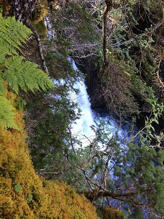
Tutka falls from overlook

Tutka Lake falls